


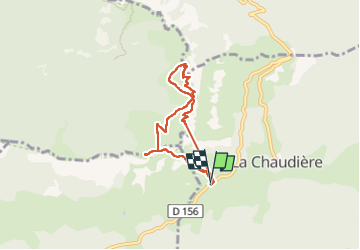
Les 3 becs

raygautier
User

Length
6.2 km

Max alt
1561 m

Uphill gradient
676 m
Km-Effort
15.2 km

Min alt
1021 m

Downhill gradient
658 m
Boucle
Yes
Creation date :
2022-06-02 06:30:03.0
Updated on :
2022-06-02 12:44:31.774
1h56
Difficulty : Difficult

FREE GPS app for hiking
 SityTrail
IGN / Geographical institutes
SityTrail Plus
The world is yours!
About
Trail Walking of 6.2 km to be discovered at Auvergne-Rhône-Alpes, Drôme, La Chaudière. This trail is proposed by raygautier.
Positioning
Country:
France
Region :
Auvergne-Rhône-Alpes
Department/Province :
Drôme
Municipality :
La Chaudière
Location:
Unknown
Start:(Dec)
Start:(UTM)
674868 ; 4944138 (31T) N.
Comments